The Ancile Homepage
Individual Positioning and Event Notification System
|
The Ancile Homepage
Individual Positioning and Event Notification System
|
|
What is Ancile?
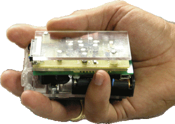
The prototype we built consists of two types of devices: an end device that is carried by the soldier, and a bridge device that is mounted on a vehicle or at an operations center. The end device looks like a slightly oversized pager and runs on standard AAA batteries.
Does it actually work?
Yes. Field testing was performed during a live mortar fire event at Yuma Proving Ground, Arizona in April of 2005. The basic premise of the test was that if the Ancile system was connected to the warning systems on a local area network (LAN), the pagers should generate alarms correctly. Since Ancile is designed to operate with no user intervention, the test was conducted likewise. All system inputs came from the network interfaces. The only interaction with the system components was in setting them up for the test and in collecting data between trials. In a series of tests, the Ancile pagers were correctly stimulated by the sensor systems with no required changes to the later beyond providing them the internet protocol (IP) address of the Ancile bridge. In all cases but one, rounds launched at the northern impact area triggered the pager that was configured with static coordinates that placed it in that area. Similarly, rounds launched at the southern impact area triggered an alarm on the south pager. After detecting many mortar rounds, the only instance of a round not triggering an alarm occurred when pager erroneously calculated the POI as being 50 meters further away from the pager than it actually was. After examining the code, we found that a simplifying assumption in the algorithm that calculates the distance between the pager and the POI was to blame. We independently calculated the error introduced by this assumption as almost exactly 50 meters at the latitude and longitude of the test site. |
All information on this page is approved for public release
Maintained by LTC Fernando J. Maymí
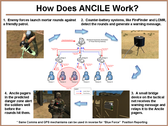
 Ancile is a prototypical information system that warns dismounted soldiers of incoming indirect fire
attacks while reporting their location to existing command and control systems. The main component of
this system is a pager-like device worn by the individual soldier. This device periodically transmits
the location of the soldier and listens for threat warnings. When a threat warning is received, the
pager sounds an audible or vibratory alarm that increases in frequency as the threat approaches.
Depending on the type of ammunition and its trajectory, soldiers may have a few seconds to well over
a minute to improve their protective posture before enemy rounds detonate near them.
Ancile is a prototypical information system that warns dismounted soldiers of incoming indirect fire
attacks while reporting their location to existing command and control systems. The main component of
this system is a pager-like device worn by the individual soldier. This device periodically transmits
the location of the soldier and listens for threat warnings. When a threat warning is received, the
pager sounds an audible or vibratory alarm that increases in frequency as the threat approaches.
Depending on the type of ammunition and its trajectory, soldiers may have a few seconds to well over
a minute to improve their protective posture before enemy rounds detonate near them.